-
Experts just found a 3D map that was carved into quartz sandstone likely 13,000 years ago.
-
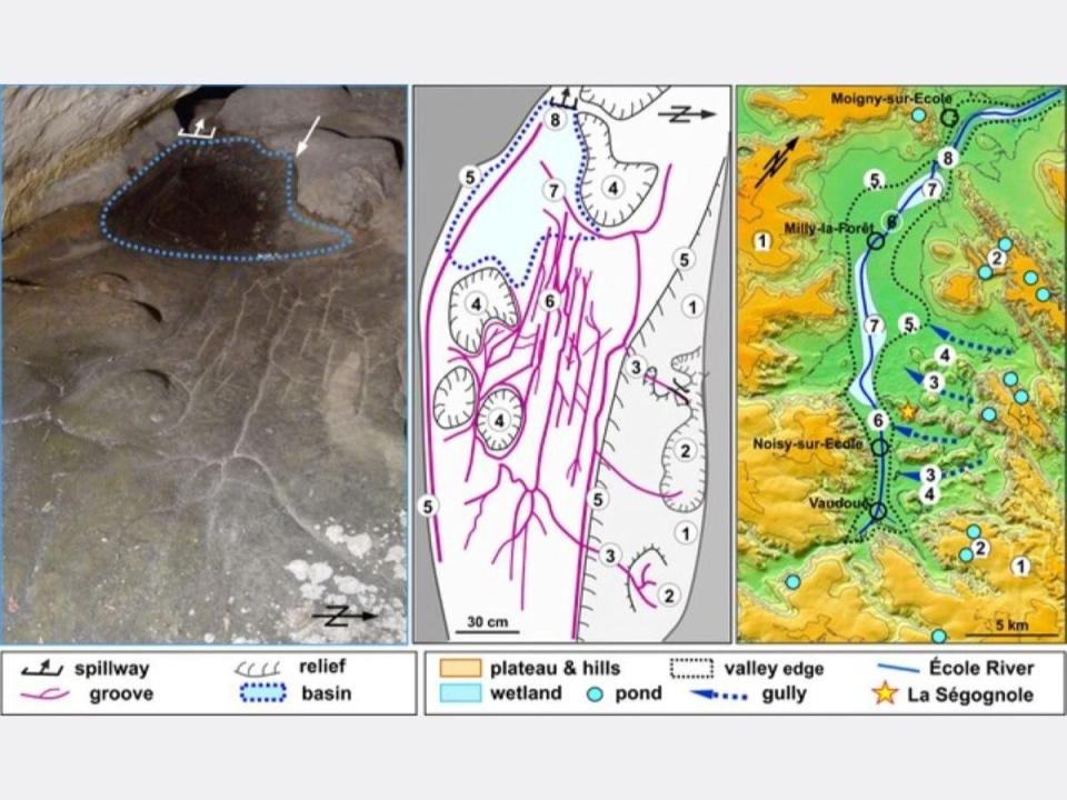
Located within the famed Segognole 3 rock shelter, researchers believe the map shows the local landscape of the Paris Basin.
-
It’s also thought to highlight natural water flows and geomorphic features, as the direction of water flow was of critical importance for the Paleolithic people.
Researchers from the University of Adelaide recently announced the discovery of a 13,000-year-old 3D map, now thought to be the oldest 3D map in the world. The team discovered this remarkable artifact carved into a block of quartz sandstone in the Segognole 3 rock shelter—a site that has long been known for artistic engravings in a Late Paleolithic style.
The map depicts what is now known as France’s Paris Basin and the surrounding landscape, with the particulars revealed in a study published by the Oxford Journal of Archaeology. It was found, according to the authors, alongside a “female sexual configuration associated with a horse engraving, stylistically attributed to the Upper Palaeolithic,” both of which were discovered in the 1980s.
“What we’ve described is not a map as we understand it today—with distances, directions, and travel times,” Anthony Milnes, co-author of the study, said in a statement, “but rather a three-dimensional miniature depicting the functioning of a landscape, with runoff from highlands into streams and rivers, the convergence of valleys, and the downstream formation of lakes and swamps.”
“For Paleolithic peoples,” Milnes continued, “the direction of water flows and the recognition of landscape features were likely more important than modern concepts like distance and time.”

Médard Thiry
The new find bests the previous oldest-3D-map record-holder—a Bronze Age engraving on a portable slab, which showed a local river network with the surrounding landscape and was likely used for navigation—by about 10,000 years.
The study authors wrote of the newly-discovered map that a network of channels engraved onto the shelter floor form a “functioning representation of watercourses. The carved motifs and their relationship with natural features in the sandstone of the shelter can be compared with major geomorphological features in the surrounding landscape.”
“Our study demonstrates that human modifications to the hydraulic behavior in and around the shelter extended to modeling natural water flows in the landscape in the region around the rock shelter,” Milnes said. “These are exceptional findings and clearly show the mental capacity, imagination, and engineering capability of our distant ancestors.”
Medard Thiry, who lead the project, noted that the creators of the map opened fractures in the stone to direct water through the site. He concluded that several fine-scale morphological features in the sandstone could not have formed naturally, showing that Paleolithic humans sculpted the stone to define specific flow paths for rainwater—something that hadn’t been recognized previously by archaeologists at the site.
The ancient landscape map was certainly about water, but in a way, we still may not fully grasp the true fullness of its meaning. “The fittings probably have a much deeper, mythical meaning, related to water,” Thiry said. “The two hydraulic installations—that of the sexual figuration and that of the miniature landscape—are two to three meters [6.5 to 10 feet] from each other and are sure to relay a profound meaning of conception of life and nature, which will never be accessible to us.”
You Might Also Like
#Archaeologists #Oldest #Map #World


Leave a Reply