It’s no secret when we hear the words “winter storm” it can cause anxiety or make you wonder how this will affect your plans.
In modern times, with so much information available at everyone’s fingertips, many weather enthusiasts or third-party weather sites will post a variety of maps and information online and on social media. But who and what should you believe? How should you plan ahead when the potential exists for a winter storm system to move into our area?
The Challenges of Winter Weather Forecasting
Winter weather presents its own unique challenges: dealing with many details, including timing and precipitation types, but also because driving in winter weather has its own set of implications. A 20-50 mile jog in a storm’s track can mean the difference between you getting 4-6″ of snow, an inch of ice, or possibly nothing at all.
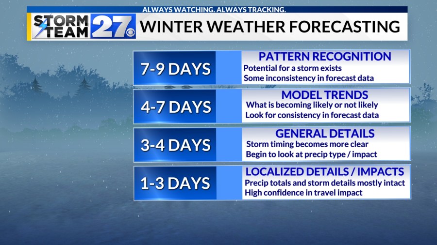
The other challenge of winter forecasting is that these details often take time to iron out. The chart below shows what to look for when checking on winter weather forecasts.

It is important to exercise caution when scrolling the internet for weather information. Often on social media, since weather forecasting data is now more readily available, anyone can post any computer model data and spread possible panic. It is important to remember that one computer model is not a forecast.
If you’re seeing posts with a storm 7-9 days away, remember that things can and often do change as the system gets closer. It is at this point in the forecast that meteorologists look for a general pattern and see that the potential pieces are in play for a winter weather event. It is likely, though, that inconsistency in model data makes specific details of your location almost impossible to predict. You can begin to think ahead and know that your plans may have to be adjusted should the storm materialize.
Once a storm system is around 4-7 days away, meteorologists look at trends and see where consistency lies in the data. It is at this point in the forecast where you often hear about the potential impacts of the storm system but there are still plenty of questions about specific impacts.
It is not until a few days out that exact details come into clearer focus. Forecasting data can resolve the specific details that make the forecast difficult. Once you get within 24-36 hours of the event, most of the details are ironed out, but things can still change. Always check the latest forecasts.
How this looks in reality
With all this in mind, let’s look at the next storm system affecting the country this week. The two maps below are forecasts from computer model data at 1:30 p.m. Wednesday, 60 hours ahead of the 1:30 a.m. Saturday time they are simulating.
What to note between the two images: the time and placement of the storm as a whole are pretty similar. Places from the lower Great Lakes to the Florida Gulf Coast are likely to see some form of precipitation to impact travel and other plans.
You can also note very small differences but differences that would make a major impact in specific locations. North Carolina is one of those places. Note that in one simulation, there’s more snow for North Carolina while in the other one, there is more of a mix and ice. This is because there are just enough differences in the atmospheric variables that can play a major role in precipitation type.


This is why winter weather forecasting has its unique set of challenges that aren’t present at other times of the year.
What this means to you
To sum this all up, in winter especially it can appear that there is often “hype” for winter weather events. In reality, with so many sources for information in the modern world, it is better to stick with your trusted local meteorologists’ forecasts, read their discussions and posts, and listen to their on-air forecasts than to look at one post of one model a week in advance.
Meteorologists take multiple computer model data over the course of many days and present their work to the public and on air. A good forecaster will communicate uncertainty, what can change, and how impacts will be felt.
Storm Team 27 is here all winter long to help you plan your day, to keep you alert to changing weather conditions and to make sure you are informed with the most accurate information at the time.
#Clicks #Science #caution #winter #forecasts


Leave a Reply