We celebrate Groundhog Day today, but not the prediction. Punxsutawney Phil saw his shadow, so he says six more weeks of winter.
Obviously, we take it with a grain of salt. Our actual forecast has more topsy turvy temp swings and a system moving through New England every couple of days through the 10-day.
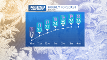
Sunday was the coldest morning in Boston all season, with 9 degrees recorded at Logan Airport. Temps ran 20-40 degrees colder compared to Saturday morning, with wind chills below zero in many communities. A few ocean effect flurries linger around the South Shore, Cape, Boston and Cape Ann through midday. Then a south wind bumps temps to the 20s with more clouds developing.

When will it start snowing in Massachusetts?
Our next clipper system moves through New England Sunday night, bringing us light snowfall.
The timing of this overnight snow will be 8 p.m. in western New England, with snow filling in around Boston 9-10 p.m. Midnight is when everyone experiences the heaviest snow, then the snow tapers from west to east before sunrise.


How much snow will we get in Massachusetts on Sunday?
We’re done with snowfall by daybreak Monday and we’re left with 1-3 inches all over southern and central New England. Less at the coasts, closer to around 3 inches of snow in the Worcester Hills and isolated spots in the Berkshires & southern Green Mountains with over 3 inches of snow.
Then our temps rise to the 40s by Monday afternoon with some melting. More 40s are on the way for Tuesday.

Thursday storm could bring snow, ice and rain
Midweek temps fall a bit to the 30s as a larger low pressure system heads our way. Thursday morning we may begin as ice, changing to rain by noon time with snow in mountains. This is subject to change, with a track and timing still to be determined.
Stay tuned for the latest weather updates all week on this storm.

#snow #Mass #NECN


Leave a Reply