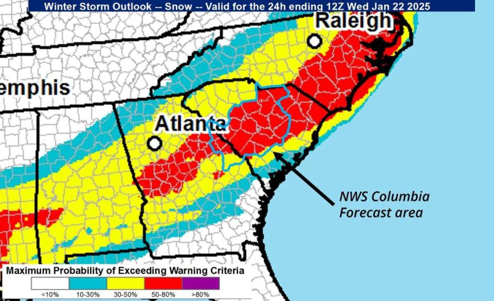
Chances are increasing that there will be snowfall in the Columbia area of South Carolina early this week, according to the National Weather Service.
The forecast shows snow is likely in the Midlands, beginning Tuesday afternoon. It could stick around for days, even after it stops falling, National Weather Service Meteorologist Emily Carpenter told The State Sunday.
The forecast isn’t clear about how much snow will accumulate, but even if it’s a dusting the flakes could linger because temperatures will be so cold that the frozen precipitation might not melt, according to Carpenter.
“There’s a lot of uncertainty about how much snow we get, but temperatures this week will be very chilly,” Carpenter said. “Temperatures could be in the teens, especially in the morning, and the wind chill could make it feel like the single digits.”

Winter weather is forecast to affect South Carolina.
Snow flurries could begin Tuesday afternoon, anywhere from 3-8 p.m., according to Carpenter. The snowstorm is expected to continue through Wednesday morning, according to the National Weather Service.
“There’s high confidence in snow,” said Carpenter, who added that the current forecast shows a 65-85% chance of precipitation in the Midlands on Tuesday.
It’s almost certain that any precipitation will be snow because of the freezing temperatures in the forecast.
While there is still some uncertainty in the forecast, anywhere from half an inch to 2 inches of snow could fall in the Columbia area, according to Carpenter. Localized amounts in other areas could be higher, especially in the southern and eastern parts of the Midlands, Carpenter said.
There will be a sharp cutoff from where snow will fall, to no snow at all. The edge will likely fall west of Columbia, more toward Chapin and Newberry, according to Carpenter. Those areas were more significantly impacted by the Jan. 10 winter storm that included some snow, sleet and freezing rain.
Neither sleet nor freezing rain is expected to be included in this week’s winter weather storm, Carpenter said. “Super strong winds” also are not in the forecast, so downed trees and power outages don’t figure to be as much of an issue, according to Carpenter.

Freezing temperatures are forecast to affect South Carolina.
But the extreme cold will be a factor in this event.
“It’s going to be so cold that we don’t see other precipitation being a threat,” Carpenter said.
Snow could cause treacherous driving conditions, but the freezing temperatures could also lead to hazards on the roads. Wednesday’s high is forecast to be 34 degrees, so some snow could melt, and should that happen the drop to an overnight low of 15 degrees — the coldest point of the week — could lead to a refreeze, with ice and black ice potentially forming, according to Carpenter.
Midlands residents might need to cover pipes and outdoor water spigots, while letting indoor water faucets drip overnight to prevent bursting, the National Weather Service said. People will want to bring in pets as well as sensitive plants and other vegetation, according to the National Weather Service.
Livestock owners will need to check on their animals to ensure they are warm enough and that their water has not frozen, Carpenter said.

The National Weather Service provides guidance about how to dress for cold temperatures.
A slight thaw is in Friday’s forecast, at least during the day when highs in the 40s are possible. Overnight temperatures could drop to 23 degrees, according to the forecast. It will continue to get warmer Saturday, when a high of 50 is possible, Carpenter said.
Conditions are expected to continue to warm the following week, according to the Weather Channel.
Before that, there’s a slight chance that more snow could fall following Tuesday night’s storm.
“Another weak system could come through the area Thursday night, and there’s a possibility we could see another round of snow,” Carpenter said.
That could potentially be the third snowstorm of 2025, in an area where any freezing precipitation is considered rare. Prior to the Jan. 10 storm, the last time there was snow on the ground in the Columbia area was January 2022, according to the National Weather Service. Between 1 and 3 inches of snow was recorded across the Midlands during that winter storm.
That storm was the first time any measurable amount had fallen on Columbia since 2017, and prior to that Columbia hadn’t had more than an inch of snow since 2014, the National Weather Service said.
#Snow #Columbia #Heres #fall #forecast #start


Leave a Reply