As we move into late-week, a significant winter storm is becoming more likely for much of Arkansas. While forecast details are still subject to change, here’s what we know so far.

Timing
- Thursday Morning: Snow showers could begin as early as 7 AM in parts of southwest Arkansas, including Texarkana, De Queen and Ashdown.
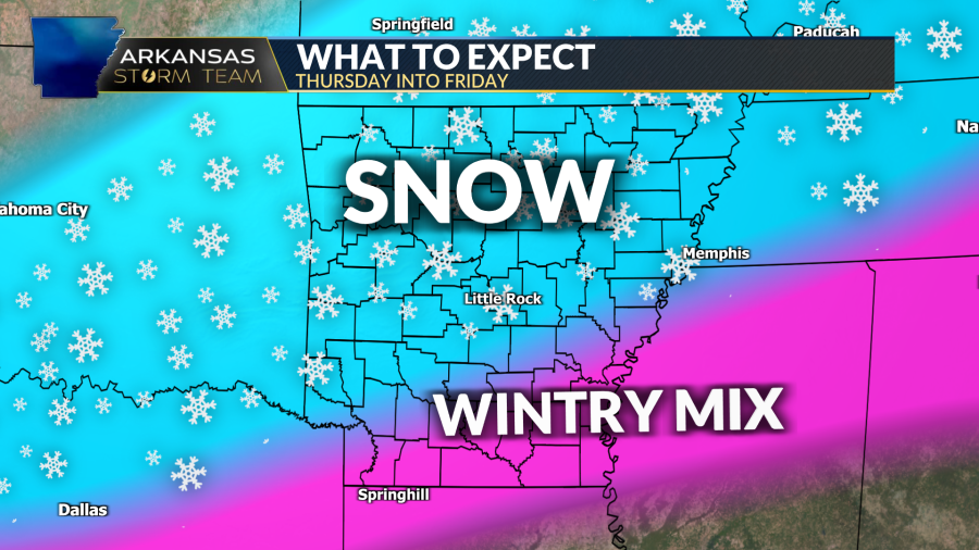
- Thursday Afternoon/Evening: Precipitation spreads statewide, with snow likely along and north of I-30 and I-40. South Arkansas may see a wintry mix of sleet, freezing rain, and eventually snow as colder air moves in.
- Friday: Snow continues through the morning and afternoon, gradually tapering off into the evening. Lingering flurries may last into the overnight.
Threats and Impacts
- Travel Hazards
- Icy and snow-covered roads will make travel dangerous statewide, especially during peak snowfall Thursday evening into Friday.
- Areas south of US-270 and into eastern Arkansas could see sleet and freezing rain, adding an icy glaze to roadways.
2. Snow Accumulations
- Southern Arkansas: A wintry mix transitioning to snow could lead to lighter but still impactful accumulations. Perhaps a dusting to 3 inches of snow could cover the ice seen earlier in the storm.
- Southwest, West and Central Arkansas: This is where the heaviest snowfall totals will be possible, perhaps 3-7 inches. Some higher amounts are possible.
- Northern and Northeast Arkansas: About 3-5 inches of snow is expected in these areas.
- Northwest Arkansas: With less moisture in this part of the state, expect smaller amounts between 1 and 3 inches.
3. Cold Temperatures
- Bitter cold persists through the weekend, with highs near freezing and overnight lows in the teens and 20s. Any melted snow will likely refreeze, extending travel difficulties into Saturday and Sunday. This may linger into early next week as well.

Looking Ahead
Areas that see heavier snowfall totals will take longer to melt. This could leave lingering impacts into early next week, potentially affecting school and work schedules as roads gradually thaw.
Stay Prepared
- Download the Arkansas Storm Team App for updates, alerts, and forecast adjustments.
- Prepare for prolonged cold, and avoid unnecessary travel during the peak of this storm.
Stay safe and stay tuned for updates as we track this winter storm!
#Winter #Storm #Alert #Timing #Threats #Impacts #LateWeek


Leave a Reply